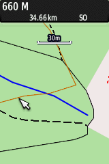
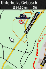
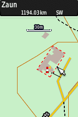
FRANCE - Leucate Plage
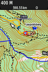
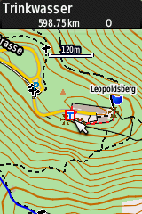
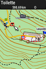
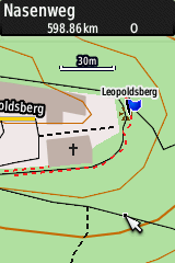
AUSTRIA - Leopoldsberg
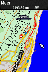
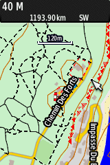
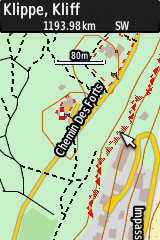
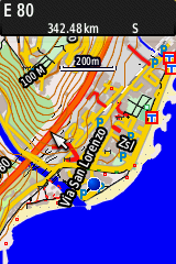
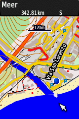
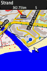
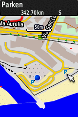
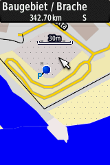
ITALY - Cogoleto
 English
 Deutsch
Additional maps may safely be stored on your GPS-device as follows:
a) Buy an additional Micro-SDHC-Card and insert it (for my GPSMAP64 max. 32GB)
b) On the new storage device create a directory called Garmin
c) Download the compressed map from this web-site to a PC (e.g. switzerland.zip)
d) Decompress the map on your PC: Linux: unzip switzerland.zip; Windows: e.g. with 7-Zip)
e) Copy the map (e.g. switzerland-PICO_61049.img) to your GPS device (into the directory Garmin on
the additional storage device)
According to reports from colleagues, the OSM-maps provided here work on
the following devices:
Garmin fenix 6X Pro Solar (watch),
Garmin eTrex 20, Garmin eTrex Touch 35, Garmin GPSMAP 64, Garmin GPSMAP 64s,
Garmin nüvi 3590 LMT,
Garmin Oregon 200, Garmin Oregon 450t, Garmin Oregon 550,
Garmin Oregon 600, Garmin Oregon 650, Garmin Oregon 700,
Garmin Dakota 20, Garmin Montana 650,
Garmin Montana 680, Zümo 590, Garmin-Asus nüvifone A50,...
(Your feedback to extend this list is highly appreciated!!)
The newly copied maps to your GPS device do not appear in the display?
On my GPSMAP64 I currently have 16 maps (all of them PicoMaps) with a total
of 11.5 GB of *.img files on an additional storage chip and they work
well. Should a map not been displayed, although it is activated, it is
recommended to remove other maps and to try it again. The only source
describing the limits of maps I found so far is this one from
Garmin.
According to this site the GPSMAP64-series has a limit of approx. 3000 tiles.
The current amount of tiles of the 16 stored maps on my GPS is 3288.
I will test soon, how many additional maps/tiles I will be able to load
on my device.
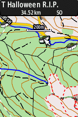
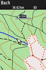
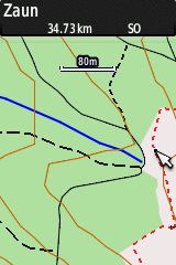
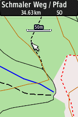
The examples below depict various zoom-levels of the generated
OpenStreetMaps (OSM-maps) typically used while geocaching for areas
in Switzerland, France, Austria, and Italy.
The text in the black field on top of the screenshots of the GPSMAP64
indicates, on what item the cursor (white arrow) points to.
FRANCE - Leucate Plage
AUSTRIA - Leopoldsberg
ITALY - Cogoleto
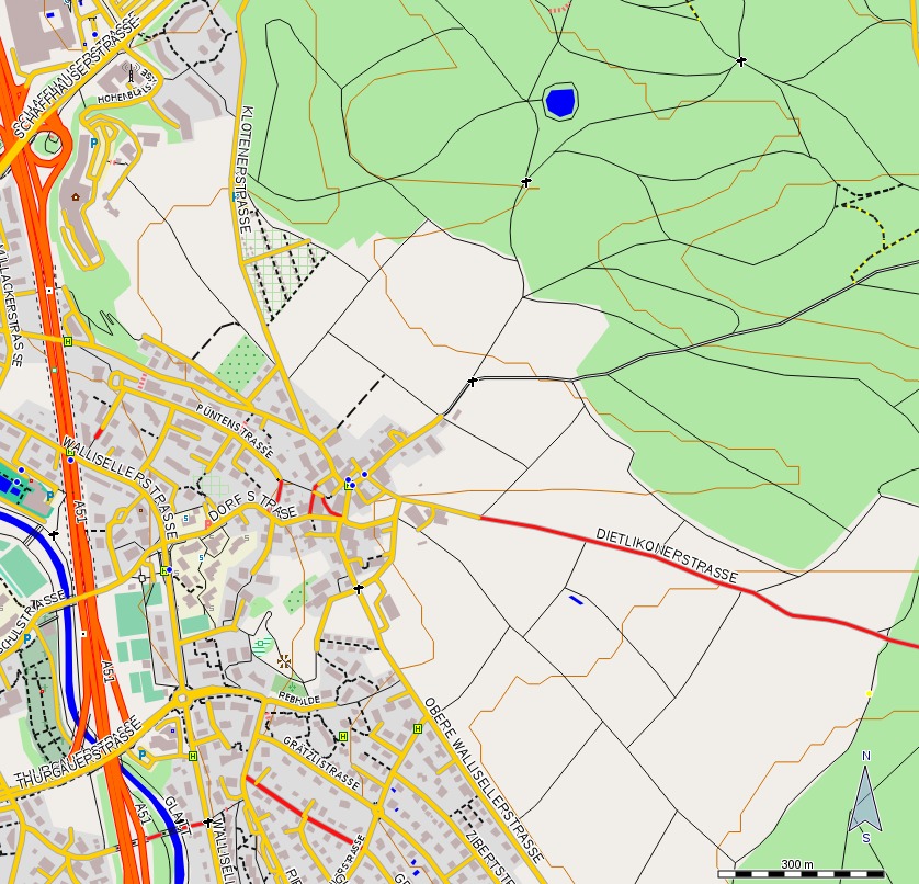
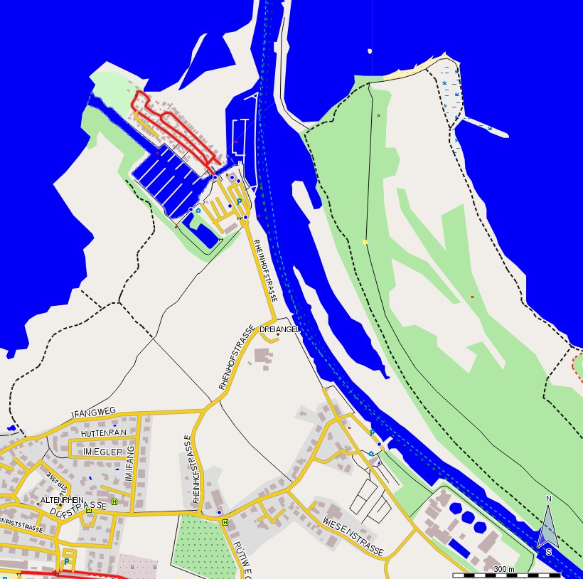
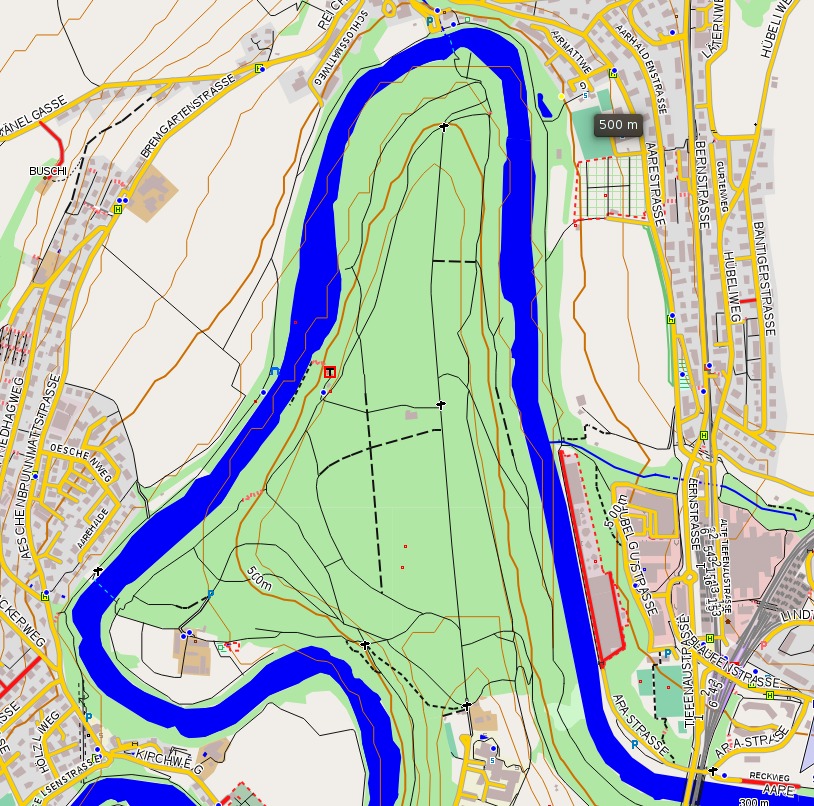
Three larger Maps may be found here: Opfikon near Zurich, Altenrhein at the Lake Constance and Engehalbinsel near Berne.
All PicoMaps offline maps are optimized for geocaching. Differentiation of
the various forest types are omitted, because such information is not relevant
while searching for geocaches, and because they are irritating. Lakes and creeks
are depicted in dark blue in order to clearly show them also in forest areas.
Fences and cliffs are shown in red, as they represent important obstacles and
may be dangerous while geocaching.
Places with drinking water (red-surrounded blue 'T'), toilets (red-surrounded
black 'T'), and subway-entrances (white 'U' on blue ground) are specially
marked.
PicoMaps are topographic maps: Contour lines are depicted in brown color every
10m and every 100m they are drawn as fat lines. Contour lines are important
for us in order to choose the most suited way/path while caching.
For better recognition state boundaries are drawn in green and with a special
signature. We use the same color - but with a thinner line) for boundaries
of cantons (Switzerland), German federal states and US states.
Freeways ('Autobahnen') appear in a dark orange color and all of the other
streets of any kind in a golden yellow. Restriced streets are drawn
in a bright red.
Following a wish of many users, routing for paths in forests has been activated
again. Thus, the exact type of the way may not appear very exactly when
zooming into the map (e.g. "[Radweg]" instead of "Bergweg").
The maps are capable for routing and usage in a car. However, the
pre-installed Garmin-maps in the GPS-devices for cars seem to be much more
user-friendly.
The style (here PICO) and the family-ID of the provied maps are contained in the
names in order to allow differentiation of the loaded maps from each other.
Should houses not appear anymore in the maps or should any other unexptected
effects appear on the maps, it is recommend to de-activate all maps of the
surrounding areas (map - menu - maps - choose map - select map and deactivate
it). Usually I got the best results if there is only one map activated.
The family-ID of all maps available here ranges between 61000 and 62000 and
is different for each of the maps, so they do not get into conflict with other
maps installed.
The list of freely downloadable maps will be extended from time to time and the
individual maps
are updated at irregular intervals.
The date stands for the generating time and thus for the currentness of the
underlying OSM map data. The size of the downloadable zip-files is given in
brackets. Attention: The unzipped maps of the type *.img are approx.
30-40% larger than the downloaded zip-file!
Whenever possible, the overview-maps have been generated using the software
QLandkarteGT.
The list of available maps is first sorted according to the large regions
(AFrica,
ASia, CentralAmerica, EUrope and Near East,
South America), OCeania, the
USA, and alphabetically within these large regions.
- AF Morocco: morocco.zip (476M) -> morocco.img (538M)- Overview / Übersicht 29Mar2025-01:37
- AF Tunisia: tunisia.zip (94M) -> tunisia.img (114M)- Overview / Übersicht 30Mar2025-07:20
- AS Cambodia: cambodia.zip (93M) -> cambodia.img (109M) - Overview / Übersicht 12Sep2025-03:34
- AS Indonesia (no contour lines / ohne Höhenlinien!): indonesia_oHL.zip (126M) - Overview / Übersicht 17Nov2015-22:22
- AS Nepal: nepal.zip (536M) -> nepal.img (622M)- Overview / Übersicht 29Mar2025-03:14
- AS Philippines: philippines.zip (602M) -> philippines.img (746M)- Overview / Übersicht 29Mar2025-14:13
- AS SaudiArabia, Oman, Katar, Bahrein, VAE: gcc-states.zip (1.2G) -> gcc-states.img (1.4G)- Overview / Übersicht 28Mar2025-03:18
- AS Thailand: thailand.zip (665M) -> thailand.img (789M)- Overview / Übersicht 30Mar2025-07:05
- AS Vietnam: vietnam.zip (716M) -> vietnam.img (844M)- Overview / Übersicht 12Sep2025-03:12
- CA Costa Rica: costa-rica.zip (84M) -> costa-rica.img (95M)- Overview / Übersicht 27Mar2025-10:57
- EU Albania: albania.zip (79M) -> albania.img (89M)- Overview / Übersicht 27Mar2025-03:40
- EU Andorra: andorra.zip (4.3M) -> andorra.img (4.9M)- Overview / Übersicht 27Mar2025-03:43
- EU Austria: austria.zip (669M) -> austria.img (788M)- Overview / Übersicht 27Mar2025-06:36
- EU Austria-bigplus: austria-bigplus.zip (2.5G) -> austria-bigplus.img (3.1G)- Overview / Übersicht 6Jan2021-11:28
- EU Azores: azores.zip (12M) -> azores.img (15M)- Overview / Übersicht 27Mar2025-06:45
- EU Belgium: belgium.zip (269M) -> belgium.img (346M)- Overview / Übersicht 27Mar2025-07:19
- EU Bosnia-Herzegovina: bosnia-herzegovina.zip (179M) -> bosnia-herzegovina.img (202M)- Overview / Übersicht 27Mar2025-10:28
- EU Canary Islands: canary-islands.zip (41M) -> canary-islands.img (51M)- Overview / Übersicht 27Mar2025-10:39
- EU Croatia: croatia.zip (179M) -> croatia.img (210M)- Overview / Übersicht 27Mar2025-11:41
- EU Cyprus: cyprus.zip (33M) -> cyprus.img (41M)- Overview / Übersicht 27Mar2025-11:50
- EU Czech Republic: czech-republic.zip (423M) -> czech-republic.img (511M)- Overview / Übersicht 27Mar2025-12:59
- EU Denmark: denmark.zip (234M) -> denmark.img (305M)- Overview / Übersicht 27Mar2025-13:32
- EU Estonia: estonia.zip (78M) -> estonia.img (97M)- Overview / Übersicht 27Mar2025-13:49
- EU Faroe-Islands: faroe-islands.zip (7.0M) -> faroe-islands.img (8.3M)- Overview / Übersicht 27Mar2025-13:52
- EU Finland: finland.zip (642M) -> finland.img (768M)- Overview / Übersicht 27Mar2025-15:54
- EU France (incl. Monaco): france.zip (2.6G) -> france.img (3.3G)- Overview / Übersicht 27Mar2025-23:59
- EU Germany: germany.zip (2.4G) -> germany.img (3.1G)- Overview / Übersicht 28Mar2025-08:32
- EU Great Britain (incl. Isle of Man): great-britain.zip (1.3G) -> great-britain.img (1.7G)- Overview / Übersicht 28Mar2025-11:52
- EU Greece: greece.zip (374M) -> greece.img (430M)- Overview / Übersicht 28Mar2025-12:53
- EU Hungary: hungary.zip (184M) -> hungary.img (236M)- Overview / Übersicht 28Mar2025-13:59
- EU Iceland: iceland.zip (121M) -> iceland.img (132M)- Overview / Übersicht 28Mar2025-14:28
- EU Ireland & Northern Ireland: ireland-and-northern-ireland.zip (254M) -> ireland-and-northern-ireland.img (324M)- Overview / Übersicht 28Mar2025-15:19
- EU Israel & Palestine: israel-and-palestine.zip (85M) -> israel-and-palestine.img (109M)- Overview / Übersicht 28Mar2025-15:32
- EU Italy (incl. Vatican & San Marino): italy.zip (1.8G) -> italy.img (2.1G)- Overview / Übersicht 28Mar2025-22:45
- EU Jordan: jordan.zip (51M) -> jordan.img (60M)- Overview / Übersicht 28Mar2025-23:01
- EU Kosovo: kosovo.zip (34M) -> kosovo.img (40M)- Overview / Übersicht 28Mar2025-23:07
- EU Latvia: latvia.zip (101M) -> latvia.img (124M)- Overview / Übersicht 28Mar2025-23:21
- EU Lebanon: lebanon.zip (40M) -> lebanon.img (49M)- Overview / Übersicht 28Mar2025-23:30
- EU Liechtenstein: liechtenstein.zip (2.4M) -> liechtenstein.img (2.8M)- Overview / Übersicht 28Mar2025-23:31
- EU Lithuania: lithuania.zip (143M) -> lithuania.img (178M)- Overview / Übersicht 28Mar2025-23:45
- EU Luxembourg: luxembourg.zip (26M) -> luxembourg.img (32M)- Overview / Übersicht 28Mar2025-23:50
- EU Macedonia: macedonia.zip (52M) -> macedonia.img (56M)- Overview / Übersicht 29Mar2025-00:00
- EU Malta: malta.zip (4.7M) -> malta.img (6.4M)- Overview / Übersicht 29Mar2025-00:03
- EU Montenegro: montenegro.zip (44M) -> montenegro.img (49M)- Overview / Übersicht 29Mar2025-00:14
- EU Netherlands: netherlands.zip (433M) -> netherlands.img (573M)- Overview / Übersicht 29Mar2025-04:32
- EU Norway: norway.zip (1.6G) -> norway.img (1.8G)- Overview / Übersicht 29Mar2025-12:36
- EU Portugal (incl. Madeira): portugal.zip (251M) -> portugal.img (315M)- Overview / Übersicht 29Mar2025-14:56
- EU Slovakia: slovakia.zip (219M) -> slovakia.img (261M)- Overview / Übersicht 29Mar2025-15:48
- EU Slovenia: slovenia.zip (215M) -> slovenia.img (247M)- Overview / Übersicht 29Mar2025-16:32
- EU Spain (incl. Balearic Islands, excl. Andorra; Canary Islands: separate maps!): spain.zip (1.6G) -> spain.img (1.9G)- Overview / Übersicht 29Mar2025-23:25
- EU Sweden: sweden.zip (848M) -> sweden.img (999M)- Overview / Übersicht 30Mar2025-03:36
- EU Switzerland: switzerland.zip (400M) -> switzerland.img (480M)- Overview / Übersicht 31Mar2025-03:58
- EU Switzerland-bigplus: switzerland-bigplus.zip (3.0G) -> switzerland-bigplus.img (3.7G)- Overview / Übersicht 30Mar2025-22:38
- EU Switzerland-plus: switzerland-plus.zip (1.1G) -> switzerland-plus.img (1.3G)- Overview / Übersicht 31Mar2025-03:16
- EU Syria: syria.zip (99M) -> syria.img (121M)- Overview / Übersicht 30Mar2025-05:37
- EU Turkey: turkey.zip (1.3G) -> turkey.img (1.4G)- Overview / Übersicht 30Mar2025-10:46
- OC Fiji: fiji.zip (30M) -> fiji.img (34M)- Overview / Übersicht 27Mar2025-14:01
- OC French Polynesia: polynesie-francaise.zip (14M) -> polynesie-francaise.img (17M)- Overview / Übersicht 29Mar2025-14:23
- SA Bolivia: bolivia.zip (765M) -> bolivia.img (835M)- Overview / Übersicht 27Mar2025-09:47
- SA Haiti & Dominican Republic: haiti-and-domrep.zip (124M) -> haiti-and-domrep.img (148M)- Overview / Übersicht 28Mar2025-13:17
(Number of currently available maps: 60; Maps currently in progress: --)
These maps were generated using data from the OSM-project
(http://www.openstreetmap.org/), specifically from Geofabrik.de
(http://download.geofabrik.de/), contour lines from NASA (SRTM) and other
sources with digital contour-models (both using phyghtmap
(http://katze.tfiu.de/projects/phyghtmap/), configuration files of the project
'Freizeitkarte' (http://freizeitkarte-osm.de/), various open-source-software
such as e.g. mkgmap (http://www.mkgmap.org.uk/), and software from TheRaven and
PicoKnirps.
A big "thank you* belongs to all the mappers, who contribute to the extension
and improvement of the OSM-maps used for this project.
The design of the maps provided here (PicoMaps) was established using styles
from various sources and has been strongly modified and extended.
The look of the maps was designed according to our needs (Team PicoKnirps) while
caching at various regions; some useful suggestions from colleagues have been
implemented as well.
These maps are under the license CC-BY-NC-SA-4.0 (approriate credit, non-commercial, share alike under the same license).
Any liability for the download, installation and usage of these maps is excluded.
Themes/Styles for c:geo, if the maps
Freizeitkarten
are installed there. With this style, the maps look similar as the OSM maps
available above using the style PICO:
Download freizeitPKtheme_24Apr21.zip
A detailed description and instructions on how to install it is available here:
c:geo
MOSLIBOSS Smarthome: Modular, safe, linux based